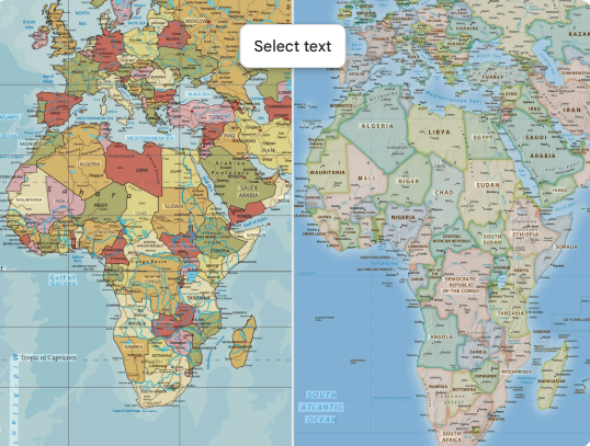

The United Nations General Assembly has backed a resolution promoting the use of a world map that more accurately reflects the true size of Africa and other land masses, in a move strongly supported by African countries.
The resolution, known as “Correct the Map,” was adopted on September 4, 2026, after being introduced by Togo on behalf of the African Group. It encourages wider use of the Equal Earth projection, which represents the relative surface areas of countries and continents more accurately than the widely used Mercator projection.
The resolution was adopted by 164 votes to one, with six abstentions, with the United States casting the only vote against the measure.
PETHS News checks of statements released by the United Nations and the African Union Commission, alongside reports from international news organisations, confirmed that the resolution was adopted by the General Assembly and that the United States opposed it.
The African Union Commission welcomed the development, describing it as an important step towards a more accurate and fair representation of Africa on global maps.
The resolution is, however, not legally binding, meaning countries, schools, publishers and technology companies are not required to immediately stop using the traditional Mercator projection.
The decision does not redraw Africa’s borders or create a new continent map.
Instead, it promotes a different method of displaying the three-dimensional Earth on a flat surface.
The Mercator projection, developed in the 16th century, was designed mainly for navigation and preserves direction well. However, it significantly enlarges countries and regions closer to the poles while making areas around the equator, including Africa, appear comparatively smaller.
For example, Greenland often appears close in size to Africa on Mercator maps, even though Africa is roughly 14 times larger. The Equal Earth projection seeks to correct this by preserving the relative size of land masses.
African leaders and campaigners supporting the initiative argue that the continued use of distorted maps has contributed to misconceptions about Africa’s geographical size and global importance.
Togo, which spearheaded the initiative, said a fair representation of the world should begin with a more accurate map.
The African Union has also argued that the Mercator projection significantly understates Africa’s size and has encouraged educational institutions, publishers and digital platforms to consider more accurate alternatives.
Supporters say the issue is not only geographical but also relates to how Africa has historically been represented to the rest of the world.
The United States opposed the resolution but did not dispute the established fact that the Mercator projection distorts relative land areas.
Instead, Washington questioned the need for the issue to be handled through a United Nations political resolution.
The U.S. position suggested that the General Assembly should focus on what it considers more urgent international matters.
The disagreement, therefore, is not mainly about whether the Mercator projection distorts land size, but about the political framing and international significance attached to the campaign.
Cartographic evidence confirms that the Equal Earth projection is designed to preserve the relative surface area of countries and continents.
The Mercator projection, meanwhile, becomes increasingly distorted as locations move farther away from the equator.
However, no flat map can perfectly represent the Earth in every respect. While Equal Earth better represents land area, other properties such as distance, shape and direction may still be distorted.
This also means the Mercator projection remains useful for certain navigation purposes, even though it is less suitable for comparing the relative size of continents.
The latest UN decision follows a campaign that has grown steadily across Africa.
In August 2025, the African Union publicly supported the Correct the Map campaign, calling for broader use of maps that better reflect Africa’s true geographical size.
The campaign later received stronger political backing from African leaders.
At the African Union summit in February 2026, African leaders formally endorsed the initiative, while Togo later took the campaign to the United Nations.
The September 4 vote now represents the campaign’s biggest international breakthrough.
The adoption of the resolution does not mean traditional maps will disappear immediately from schools, websites or digital platforms.
Instead, governments, publishers, educational institutions and technology companies are expected to decide whether to adopt Equal Earth or other equal-area projections.
Togo has indicated that it plans to begin introducing updated maps into its educational materials and is expected to encourage other countries to do the same.
The African Union has also pledged to work with member states and international partners to promote wider implementation.
The development is being seen as a major symbolic and diplomatic victory for Africa’s campaign for more accurate representation on the global stage.
Leave a Reply